Wansdyke home I What's New I Sitemap I Bibliography I Vortigern Studies l POLLS I LINKS l Sitemaster I FAQs
search l about Vortigern
Studies l Games I Arthurian
Collection I View Guestbook I Sign Guestbook
| Vortigern Studies > Wansdyke > Articles > Gardner (1) |
Vortigern Studies Index
Wansdyke Project 21 |
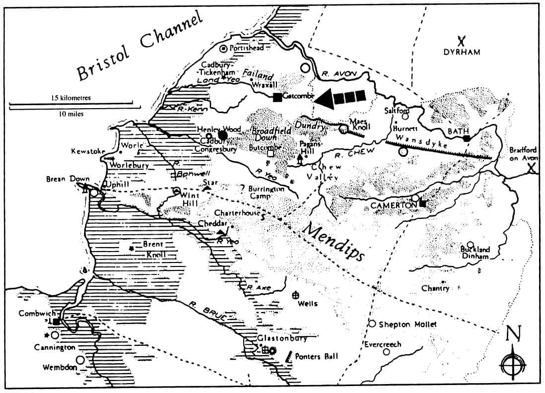
ABSTRACT This paper revives the problem in the light of a subsequent postulation that a polity based on Cadbury for the construction of the dyke in North Somerset, and considers the possible need to effectively control access from the north-east along the Ashton Vale to these two high status sites. Specific claims made by earlier field workers of evidence for a continuation of the dyke west of Dundry are again considered, and authoritative statements regarding the relationship between Wansdyke and its incorporated Hill-forts are re-examined in the light of apparently flawed observations in support of the current claim. The possibility of there being extant, maybe unfinished, and albeit even irrelevant linear earthworks between Dundry and the Avon Gorge is noted.
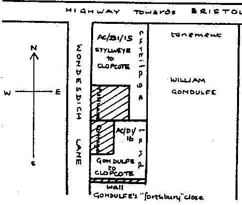
INTRODUCTION Albany Major (1929), whilst recording many field features accurately, was somewhat over-enthusiastic in his interpretation of some of them being vestiges, and indeed 'branches' of Wansdyke west of Dundry, to the extent that the very idea is now popularly regarded as a figment of his imagination. O.G.S.Crawford (1953, 252) accordingly dismissed Major's work in toto, and slated that 'the western terminus is at the hill-fort of Maes Knoll '. This was used as a basis by Fox & Fox (1960, p.1) to claim that ' The Somerset portion ends at......Maes Knoll' and in a footnote (p.1) ' There is no evidence for its continuation to the Severn estuary'. Unfortunately neither Crawford nor Fox have dismissed in detail any of the claimed evidence regarding a crossing of the Ashton Vale, discussed in the earlier publications, but have peremptorily rejected the whole suggestion out of hand. The received wisdom amounts today to a diktat; - no respectable researcher looks for Wansdyke west of Maes Knoll. This may well of course be the case, but there are various pieces of 'evidence' brought up by Collinson and Major which at least deserve to be examined, and reasons given for their dismissal, particularly as two high status Late/Sub-Roman sites are now known to exist in the 'unprotected' Ashton Vale (Fig. 1). THE EVIDENCE ? The second matter is to account for what appears to be a massive earthwork which does descend west Dundry in the direction of the Peart and Highridge Common, across which Collinson claimed the dyke ran. Collinson (1791), having written of its course being 'directed hither from the ancient fortification at Mays-Knoll', (Vol III, 140) continues '...Descending the hill it crosses Highridge Common, where its tract is still visible'. If this was in fact the case, if a man-made dyke does descend the hill towards Highridge Common then there is surely a case to pursue. In addition there are remains of several other apparently unfinished stretches of linear earthworks which should merit re-examination, if only to prove their irrelevancy. THE LAND DEEDS Fortunately the whole collection came, with the house and estate, into the hands of the Bristol Corporation and hence the Bristol Record Office, where eventually the document referred to by Collinson (AC/D.1/16) came to light and with it a second and similar deed (AC/D. 1/15). In the 1970's the two documents were photographed; and Frances Neale produced translations and comment and produced a schematic plan of the relationship of the properties to each other and to the lane system approaching the highway to Bristol (Appendix I, Fig.2). What was there in the landscape of the Ashton Vale that still merited the appellation 'Wansditch' 750/800 years after its assumed construction? If Wansdyke extended west of Maes Knoll, to leave such a place-name where is it? Was it, as claimed by Collinson, the deeply sunken lane of Yanley; the meeting of which at right angles to the Bristol highway fits the schematic plan prepared by Francis Neale? FEATURES IN THE
LANDSCAPE Lower Grove Farm,
Dundry NGR ST 5559 6742 to 5552 6725 (Plates 2
& 3) The oolitic limestone is notoriously prone to slippage, but the 'banks' on Cotswold and on Dundry are usually parallel with slope of the scarp. This feature runs at right angles to the slope. It appears to be an earth and stone bank, up to 3m in height and at least as wide across the top and comparable in size with the dyke's descent from the NW corner of Stanlonbury. It runs down the hill for 170m from below the north western 'point' of the scarp, the 'corner' of Dundry Down. It may be based on a natural feature but it is there and it has to be satisfactorily explained. Lower Court Farm,
Yanley NGR ST 548704 Stokeleigh Hill
Fort NGR ST 560 734 Summerhouse
Plantation, Ashton Court NGR ST 556 722 THE FRONTIER
FORTS Stantonbury NGR
ST 672 638 On p32 Fox & Fox state 'Stantonbury is a univallate Iron Age hill-fort enclosing some 30 acres'. It is in fact multi-vallate and the OS 1:1250 Map (ST 6763) indicates a total enclosure of about 8 acres. At first sight it appears to be one unit divided by a cross-dyke, first recorded by Major (1924, footnote p.55), somewhat like Cadcong. On closer examination it appears that the western half is primary and the eastern part, secondary, possibly in part contemporary with Wansdyke, the inner bank of which forms one side of the eastern entranceway. Again on p.30, approaching the NW comer of the fort up the Dyke Fox & Fox claim 'Bank and ditch die out as the summit is reached and can be seen ending in an open patch of ground below the former Iron Age defences (Plate viii b)'. The Dyke in fact runs right up to the corner of the ramparts, and for the last 50m or so is accompanied by an outer dyke. a feature repeated at the eastern junction and illustrated by Major (1926, p.56). Along the north side of the hill-fort, and outside the main rampart there is a terrace which appears to connect the two stretches of outer dyke. Fox & Fox (p.32) suggest that this feature might post-date the hill-fort, and Burrow (p.84) accepts the possibility and again the much maligned Major includes it in his plan (p.54). Maes Knoll
NGR ST600 660 The inclusion of even two hill-forts in this stretch of such a dyke, is unusual if not unique qv Burrow (1981, p.80). If Wansdyke was to protect the Cadcong/Cameron territory (Whittock 1988, p.3) or was part of a 'grand plan' imposed by a hypothetical HQ at Cadcong as postulated by Cadrex (1992, pp.250-1), it would-make good sense to include the dramatically situated complex of Avon hill-forts, as indeed would a continued barrier across the Ashton Vale. Burrow (1981, p.154) makes the point that the work as it stands 'effectively blocks the most ready access to the larger part of Somerset east of the Parrett; it would be even more effective with the Ashton access to Cadcong blocked. We thus have two hill-forts - Maes Knoll and Stantonbury - where the Dyke, contrary to previous reports, actually runs up into the earlier ramparts. We also have an unfinished linear bank associated in a similar way with Stokeleigh. THE PURPOSE ? The suggestion of a para-military barrier across the Fosseway is attractive; most recently Underwood (1999) has illustrated the Saxon Dyke system, showing on the smallest scale map of England and Wales, the blocking of the lcknield Way, the Ridgeway and the Fosse Way. Seen from afar this may well seem sufficient, but seen from North Somerset, from behind the dyke, even if 'the Cotswold escarpment has been outflanked' is it strategically acceptable that 'the danger of an incursion from the north has been overcome'? If this was the only route to be barred, why was it necessary to extend it to Maes Knoll? Is not the answer to block Margary's Route 540, a postulated Roman road running south-west to Mendip via the Chew Valley? qv Aston & lies (1986, p.52). If we accept that, then what about the Ashton Vale, the access route to Cadcong from the Avon and south Gloucestershire -Tratman (1962, plate 13) postulates a complex of Roman roads passing over the west of Dundry including one directed at Yanley and Gatcombe via Highridge. Branigan (1977, fig.34) shows a 'possible' road approaching Gatcombe from Long Ashton. The enigmatic bank above Highridge is directed across the Ashton Vale straight for the Stokeieigh/Burwalls hill forts, and it's line would effectively control any route from the Bristol area. In a personal communication on the matter of closing the Ashton Vale, in 1962 Lady Fox responded 'I'm afraid we did regard the Avon Gorge as a barrier, lacking local knowledge, and so did not pursue our fieldwork to the coast - there is also the tide to be considered with the river crossing, running up to Saltford originally'. Against this argument of a tidal barrier is the fact that there was actually a well documented ford below the Clifton hill forts, partially demolished as an obstacle to shipping, as early as AD 1480. and totally blown up in 1883/4. This was noted as being 'of a breadth still sufficient for a carriage', in 1821 qv Seyer(1921, p.61) and was navigable for several hours either side of low tide; see also Rutter (1829. p.273) and Dobson (1931, p.224). Other writers have commented on the poor choice of line. particularly when viewed from the work itself. However if one stands on the presumed site of the Saxon victory in AD577, Dyrham hill fort, (a most commanding promontory with sweeping 180 degree views north and south along the Cotswold escarpment) the first southern horizon one sees emerging from behind Lansdown is Wansdyke ascending the east side of Stantonbury. The line to Maes Knoll, along the natural scarp edge of Dundry and across to Stokeleigh on the Avon Gorge is clearly evident as a topographical feature. The whole southern half of the bowl of the middle Avon is seen in perspective, clearly enclosed by the arc formed by the low range of hills, backed by Mendip, and breached in the west by the unprotected (?) Ashton Gap. MAES KNOLL- BATH
Recent Research (Note 3) A further view is that the use of the dyke was short lived, and the work af a two phase construction bui to a common design and technique. Unity in design of course need not extend to construction nor imply one work. force. There is evidence elsewhere to suggest that linear earthworks were not constructed from one end to the other but by separate work-gangs in different areas, arguably based on the hillforts, qv Fox.O'Neil & Grimes (1946, p.4). The work here is now thought to have been carried out, not in a single effort, but over a number of years. The line was established by a shallow ditch and completed some time later. This implies that there was no great urgency, that perhaps a perceived threat did not materialise. This in turn supports our own speculation that an unfinished Dundry - Avon Gorge stretch could well have sporadic part finished sections, exhibiting different stages of completion, sections which were still associated with the name Wansdyke in the 14th century. Broad gaps may also be planned or be due to destruction. A series of long gaps occupied by natural barriers - rivers and ravines - reduces the length of Wat's Dyke from 38 to 22 miles qv Fox et al (1946, p.2-4). At Stantonbury the once apparent evidence of the descent of Wansdyke across the fields to the Bath - Weston road has long been ploughed away. A SUB-ROMAN
POLITY? Now the argument that it was a negotiated post-Dyrham treaty boundary, implies that the victorious Saxons, having, according to the Anglo-Saxon Chronicle, captured Gloucester. Cirencester and Bath and having killed their three 'kings', were happy to allow the British south of the Avon to construct a barrier to bar their progress into Somerset which would hold them up for some 80 years or so. On balance logic would seem lo favour the construction of a pre-Badon military frontier, in preparation for the impending advance of Saxon armies and perhaps unfinished by the time of a British victory and then regarded as no longer necessary. This would seem to fit the available evidence; strategically the whole plan would have best served by linking the heights above the Avon from Bathampton to Stokeleigh, incorporating the hill forts of Maes Knoll and Stantonbury. SUMMARY Having said all this one has to accept that there is little currently to support the Ashton Vale hypothesis other than the Land deeds, the various enigmatic earthworks and a now plausible raison d'etre. Circumstantial though these may be can we really be confident that Maes Knoll was the planned western termination of Wansdyke ? We cannot go so far as
to say we have a proven case but the discussion should
not be allowed to stultify in the face of a demonstrably
flawed diktat - are we not still justified in asking
three simple questions? There may well be three simple answers, none of them relevant to a western extension of Wansdyke, but it is surely a lapse of professional discipline not to ask the questions. CONCLUSIONS
It is suggested that with the now acknowledged high-status sites of Gatcombe and Cadcong in the extended Ashton Vale there would have been a strategic need for such an extension in the 5th/6th century. It is further suggested that, unless and until clear explanations to the contrary are forthcoming, the additional existence of the Land Deeds and of other enigmatic ditches and banks, in particular, the west Dundry earthwork, make the diktat unsafe. Note I Note 2 Note 3 BIBLIOGRAPHY
APPENDIX 1: Yanleigh, Long Ashton. Collinson 1797 Skinner 1830
British Record
Office AC/D 1/15 1310 March
14 British Record
Office AC/D 1/16 1310 March
28 The evidence of these 2 deeds therefore produces the following schematic plan of two adjoining plots, lying end to end, north/south on the east side of Wondesdich Lane where it joins the main Bristol road. The lane must clearly run up to the south side of the A370. A number of lanes still hold this position, arguably the oldest being Yanley Lane, part of which was postulated by Collinson to be the ditch of Wansdyke. APPENDIX 2: Cadcong & Wansdyke - a Speculative Model. By AD 43 the south western tidewater peninsula, from Dorset to Gloucester, was divided between three tribes, the Durotriges of Dorset and south east Somerset, the Dumnonii of Devon, Cornwall and part of west Somerset and the Dobunni of Gloucestershire and north Somerset. According to Seutonius, Vespasian with his II Legion Augusta, conquered two of these tribes 'with extreme prejudice'. One was presumably the Durotriges to judge by the evidence of a massacre at their great oppidurn of Maiden Castle, while the other could well have been the Southern Dobunni, who are major candidates for a similar sort of catastrophe at Worlebury. The Northern Dobunni are thought to have come separately to terms with Aulus Plautius, and thus avoided any recriminations. This apparent division of the Dobunni is reflected in the subsequent Civil Administration as the Imperial authority created a new Canton (of the Belgae) which included north Somerset and was administered from as far away as Winchester. The subservient Gloucestershire Dobunni were allowed their own local civitas at Cirencester (Corinium Dobunorum), thus perpetuating the division between the two sections of the tribe. On the collapse of Roman Government in Britannia the country appears to have fragmented into petty kingdoms, among which Vortigern would appear to have been some form of High King, employing Saxon mercenaries who typically rebelled and fought their former employers. Against this background Arthur is said by Nennius to 'have fought with the Kings of the Britons but was himself Dux Bellorum' The famous victory of the Britons over the Saxons at Mons Badonicus (c.AD 485 ) may well have been at a hill (fort?) near Bath, possibly at Bathhampton a few kilometers from the east end of the West Wansdyke. Some cooperative effort by 'the Kings of the Britons' was obviously achieved, a cooperation which could well have seen the construction of Wansdyke. What relationship these kingdoms had to the old Tribal structure is unclear but according to the Anglo-Saxon Chronicle for AD 577 the battle of Dyrham saw the death of three 'kings' and the capture of their three cities of Glo'ster, Cirencester and Bath - the rump of the Dobunni? By AD 584 the Saxon's westward advance appears to have been checked on what was for ever to be their frontier with the Cymru - the River Wye. What prevented them in AD 577 swinging south into Somerset having taken Bath? Not surely a 'gentleman's agreement' allowing the construction of an agreed barrier? Is it not more likely that the present area of North Somerset, behind a pre-existing Wansdyke, was so powerful a polity as to deter them from even trying? It is suggested by Morris (1973, p.307) that the one local pre-Roman tribe to have survived intact enough for Gildas to have mentioned it by name, the Dumnonii, had formed alliances with the neighbouring 'Welsh' - that is the Britons around the Bristol Channel. This alliance would seem to have been defeated c.AD 614 in a battle near Axminster and, according to Gwent traditions their peace was broken in the same year. Even so it is not until AD 658 that 'Cenwalh fought at Peonna against the Welsh and drove them in flight as far as the Parrett'. Cad Cong was contemporary with all this - or at least with Badon and with Dyrham. It's decline could be attributed archaeologically to the early 7th century - a result of the Saxon defeat of the Dumnonii in AD614? Do we see in Cad Cong a llys, the court of a local 'Welsh' king, backed by a western alliance; do we see in the adjoining temple at Henley Wood a ghost of Hen Llys, the 'Old Court', and do we see in Wansdyke the northern frontier of a latter day Dumnonia? The
Wansdyke Diktat? - A Discussion Paper Comments to: Webmaster |
VortigernStudies and
Wansdyke Project 21 are copyright © Robert Vermaat 1999-2010. |